Adjacent to the historic Butler’s Burial ground, at the end of Butler Street itself, lies a local gem of a walking spot. With its paved trail and relatively new bridge connecting two Niagara-on-the-Lake suburbs through a forest, it’s an amazing spot to get outside locally.
As you walk down below into the Niagara Peninsula Conservation Authority area, ahead of you lies Colonel John Butler’s burial ground, a character steeped in NOTL’s past. His profound influence in the late 1700s helped establish British presence in Niagara. His burial ground lies on the hillside of the very valley I’m about to explore.
Speaking of history, Two Mile Creek’s floodplain paints an artistic picture of how the water has molded the earth since Butler’s days, and the few thousand years before him.
Braided channels of the creek’s past lie empty, or simply swampy. Come spring, these arteries are filled with life again, as the majority of the conservation area sits on the floodplain.
These spillover spots create isolated vernal pools, which I was excited to stumble across. I don’t think I’ve trekked through this end of the conservation area since I was 10! I wouldn’t have fully appreciated the ecology of what I was seeing back then.
These pools, which are stagnant bodies of water, allow frogs, salamanders, and insects to breed without the presence of fish. Some of these depressions were an appreciable distance from the meandering creek, and they contained plant communities that are clearly adapted to becoming seasonally waterlogged. This also implies that the creek bed’s pattern has been constantly changing over time.
Finding these spots for my first time has me intrigued to come back here in the spring, and see or hear what amphibians might breed in these pools. Amphibians are generally good indicators of environmental health, so we should be aware of what’s in our urban conservation areas.
That’s more or less what this protected area truly is. Looking like a paintbrush of green moving from Niagara Stone Road towards Lakeshore Road, it is flanked by urban communities on both sides. The more recent developments on the north side of the area put a pinch on the open flow of this green space, ultimately creating a corridor for the creek, local hikers, and wildlife.
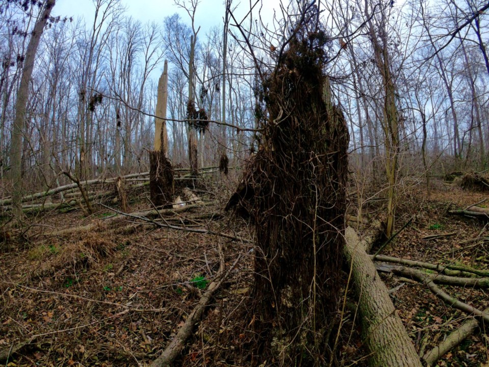
When you enter the forest, especially during this particular New Year, it becomes apparent that many of the trees are dead and down. Some have come to a resting point, but may have taken down several others with them like dominoes. Others hang on in the midst, like vertical daggers waiting for the next gust of wind to come. I found some branches stuck nearly a foot into the earth, implying they came hailing down with serious force in the wind storm from a couple months ago.
In a previous article for The Local, I made a case for our ash trees, the vast majority of which are standing as dead pillars, or have already fallen to the forest floor. It was witnessed in this floodplain forest that the ash trees created highways for the animals to perch and eat on, as evidenced by the numerous types of scat and claw marks on the wood.
Two downy woodpeckers danced around in close proximity. They were all over the exposed wood and flaking bark, picking away at the dead pillars of ash. A bird of prey, too far away to tell the species, flies a couple laps above our heads before taking a rest on the top of a tall tree. All of these crisscrossing logs on the forest floor would surely be acceptable habitat for snakes, salamanders, and foxes.
At the uprooted base of a fallen ash tree, a small, mahogany-coloured bird flew up from underground and floated away to vanish. I’ve never seen a bird fly out of the ground like that in Niagara! I have some research to do.
Amidst all the broken trees, careful observation shows how you’re standing in a flat valley of a winding creek. The ancient banks and berms on each side rise above the soggy lowlands and provide substrate for a myriad of pleasant tree surprises. The species found here generally don’t tolerate the floodplain lifestyle, so what you see is a distinguished divide in the forest created by nature and time: the valley, and the hillside.
There is a small but excellent stand of black and pin cherries on a hillside in there. Some of the red oaks and nationally rare pin oaks on these little hillsides are about 200 years old. Twisted, ancient elms with yellowy bark droop over some bends in the creek, standing out like eyesores among the scores of grey ash. I was impressed by the pockets of tree biodiversity in here, but let’s remember, they are just pockets.
Taking this trek in the winter months was both safe and rewarding. Safe from what, in the middle of an urban landscape?
Considering the death of the ash tree canopy, much of the floodplain area is infested with poison ivy, thriving in the newfound sunlight. That is not an exaggeration of the word, as some old tree stumps were my height, but you couldn’t tell it was a stump due to the thousands of wiry poison ivy vines which have enveloped it. It looked like black spaghetti. With the knowledge that some people can still contract poison ivy by touching its vine in the winter, I tried my best to steer clear, as I know I’m one of them.
I was enthused to see the clarity of the water in spots as I got closer to the edge. Although water clarity isn’t an immediate indicator of quality, it is certainly an important variable for stream health. The many logs which have fallen into Two Mile Creek have created an assortment of desirable fish habitats. The relatively wooded hills in the conservation area filter the water running into it. At this point in the creek’s stage, we’re getting very close to Lake Ontario, where the mouth of the creek empties out by the old firing range.
It’s at this exact point of entry where multiple fish species make their way upstream from Lake Ontario to spawn come spring. It’s not unusual to see large rainbow trout and sucker fish fighting the logjams and headstrong current down here.
I noted the fallen trees which have created ripple and pool effects in the creek. The woody debris can get stuck in the creek and alter the velocity and direction of the flow of the water. Sometimes, a deeper, cleaner pool ends up carving itself out behind a log, where the fish can conserve their energy, or perhaps choose to lay their eggs.
The fish habitat was evident, but as with amphibians, I would like to get back into the scrub come spring, and see which species are making use of this important fish habitat.
As four deer took silent but magnificent flight through the forest before me, I truly felt the constriction of their habitat, and the importance of this habitat corridor. Looking left and right, I could see the fringe of urban worlds. I realized the valley is wide, and narrow enough at once. In the winter air, you can see out either side of the protected area. Come summer, you would feel closed in among green foliage without a sense of depth in the forest.
The deer probably recognize this as one and the same. Maybe you’ll be fortunate enough to see deer, woodpeckers, and birds of prey on your walk down here, too.


